Posts

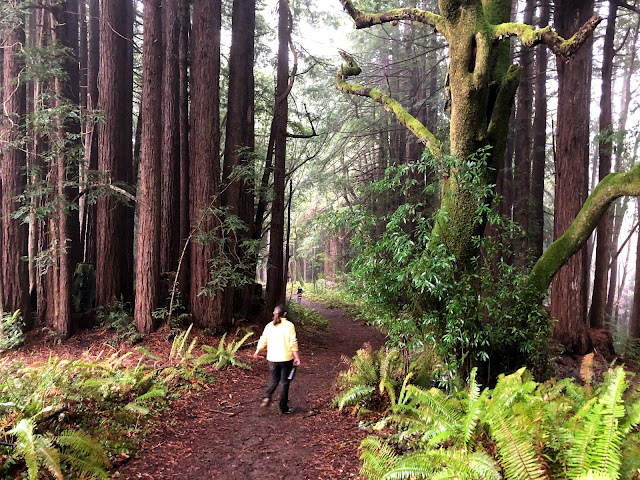
Mt. Tamalpais State Park / Cataract Trail

Image
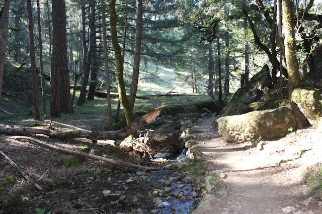
 One of my all time favorite places to hike in the North Bay is Mt. Tamalpais State Park.   I used to hike here all the time when I lived in Sausalito.  The trail I chose to hike is the Cataract Trail starting from the Rock Spring Parking lot.  I wanted to hike here because it was my favorite hike to take with my dog Bonsai.  She is now 17 years old, and we are preparing to send to her soul over the rainbow bridge.  I've been doing a lot of reminiscing about her, and all the many hours we spent hiking together.  This was our favorite trail to hike together.  It is rare for a CA State Park to allow dogs on the trail, and this park does, but you have to keep them on leash.  We actually saw some people being lectured by a Ranger about their dogs being off leash.  He gave them a warning, and he said next time it would be a $300 fine.  I used to let Bonsai off leash here all the time (oops!).  This trail is so beautiful because it runs through Redwoods, past meadows,  alongside a creek

Mill Valley / Sausalito Bike Path

Image
 My youngest and I recently took a drive down to Mill Valley and walked the multi-use trail that I used to cycle all the time when I lived in Sausalito.   It was a lovely, sunny Sunday, and she was in the mood for a long drive and listening to her favorite music.  I chose this because I knew I could park at an EV charging station and power up while we were walking.    I love this trail for the birding opportunities.  While we walked it, I believe it is better on a bike. You can go a lot farther and it branches off to Corte Madera and Tiburon.  We essentially walked from Hauke Park in Mill Valley (where there are EV chargers) to Sausalito and back - about 7 miles.  It is very scenic with Mt. Tamalpais in the back ground and wetlands all around.   The trail was quite crowded with cyclists of all varieties:  serious cyclists, tourists that rented bikes, families with little ones.  The whole gamit!  Everyone was very well behaved in navigating each other, and there was even a bicycle traf

Pomo Canyon Trail

Image
One of my favorite hikes in Sonoma County is the Pomo Canyon Trail, which is part of Sonoma Coast State Park.  It is an out and back trail that connects Pomo Canyon and Shell Beach.  Pomo Canyon is just above the Willow Creek Canyon and near the Russian.  You can start off at either Pomo Canyon or Shell Beach.  I have always started at Pomo Canyon, but I found that most people start at Shell Beach.  I love to start the hike in the Redwoods because it is so magical and beautiful.  It is my favorite redwood forest.  Always so lush, green and full of life.  The overall hike is long and sometimes strenuous, so if I decided not to go all the way to Shell Beach, at least I will have experienced my favorite part! To get to Pomo Canyon from Highway 1 and Highway 116 (just south of Jenner) cross the south side of the Russian River bridge on Highway 1. Immediately turn left (inland) on Willow Creek Road at mile marker 19.79. Drive 2.6 miles on the narrow road to the Pomo Canyon Campground turnof

Rush Creek Preserve

Image
In my search for new parks to visit, I found  Rush Creek Preserve  in Northern Novato.  It had many elements that worked for me and my youngest daughter who was joining me today:  birds, water, fit within our time window, not super strenuous (daughter's requirement). Its essentially a wetland preserve along side San Pablo Bay.  Not unlike many that I have visited already, but for me, they never get old! As you can see in the photo above, it was a combination of wetlands and oak woodlands.  We walked about 4 miles of easy trail where there were wetlands on our left and oak woodlands on our right.   The tide was high, so we saw lots and lots of ducks (mallards and common golden eye), but we did not see other sea birds that enjoy low tide and the mud flats. This park is part of the Marin County Parks, and  is right off of the 101 Freeway in Novato.  It can be accessed through several trail heads, some of which are part of neighborhoods.  Google maps did not do a good job of getting me

China Camp State Park

Image
I have been wanting to visit China Camp State Park for over a decade, and I just haven't gotten around to it.  Today I decided that this was going to be my alternative to watching the Super Bowl.  My youngest and I made the trip down to San Rafael at about 2 in the afternoon, and we did some exploring and a string of smaller hikes starting with the Turtle Back Trail.   As we entered into the park, we were treated to the gorgeous views of the San Francisco Bay, and the stunning vistas just never stopped! We made our way to China Camp Village, which was a thriving Chinese fishing village in the last couple of decades of the 1800's.  They have many of the original buildings and houses there, and it was quite interesting to imagine the thriving village.    Here are some photos: There is a Shoreline trail, which is a long trail that traverses the length of the park, but it was filled with mountain bikers.  VERY popular spot!   There  are also many vista points that are set up with

A New Commitment!

Image
 I have now been doing this for 2 months, and I have 38 posts on my blog covering 36 distinct parks in the North Bay.  I enjoyed exploring and sharing with you so much, and I have also enjoyed your feedback.   I have gotten my daughters away from their screen and out of the house, I have spent more time with friends, and more time solo in nature.  Its all been very healing and nourishing for me.  I feel my body getting stronger every day, and I have lost a little bit of weight in the process. Because I have covered so much local territory, I now have to drive a bit farther to visit new parks.   That's ok, I'm still going to do that, but I don't think I can manage it every day.  I am though going to parks everyday and revisiting many of the parks I have already written about, particularly at the coast.   Therefore, I will visit 2-3 new parks each week and share some photos from parks I already visited or even make updated posts if a new season is upon us. I have also recentl

Laguna de Santa Rosa Trail (winter update)

Image
This morning, I went for a sunrise hike the Laguna de Santa Rosa Trail.  I quickly learned that the parking lot on highway 12 is temporarily closed for repairs, so I parked at the Chevron and started off there.   I have written about this park in the Fall , but it is much different after some winter rain, so I'm writing another post about it now.  I love to walk around the Meadowlark field and close to the water.  This is where there is an abundance of life in the water and trees.  The birds, especially at sunrise are prolific here, and it is incredibly pleasurable for me to walk amongst their morning song!  I was excited that there was a beautiful tule fog today, and here was my first glance upon entering the trail: Good morning Mt. St. Helena: The initial stretch of this trail is along highway 12, and while beautiful, also has a lot of traffic noise.  It didn't take long to make the turn away from the highway and be fully immersed in bird song.  The water level was high becau